b16217731.html
Text Version
Caldwell’s Settlement at Cub Creek
Carmen J. Finley, Ph.D., CG*
Except for a few abortive attempts to establish Presbyterianism in Virginia,1 the real movement of the Scots-Irish Presbyterians into Virginia came with John Caldwell following his petition to the Donegal Presbytery in 1738 to allow him and other families of the Donegal Presbytery in Pennsylvania to migrate to “the back parts of Virginia.”2 His petition went up the chain of command in the Presbyterian structure to Governor William Gooch of Virginia who approved the petition with the provision that any Presbyterian settlement must abide by the Act of Toleration.3
Caldwell apparently did some scouting of the territory before the actual move was made.4 The territory he covered later provided the foundations for meeting houses at Cub Creek, Charlotte County (formerly Lunenburg, formerly Brunswick); Buffalo and Walkers in what is now Prince Edward County; and Hat Creek and Concord in Campbell County. Caldwell settled at Cub Creek, also known as Caldwell’s Settlement, with a reported thirty-three heads of families, or “about two hundred souls.”5
Gaines, in her Cub Creek Church and Congregation, admits to some confusion as to the year of their arrival and exact location of their first settlement.6 The earliest deeds for the Cub Creek property were recorded 1 January 1745 in Brunswick County. However, it is possible to pinpoint Caldwell’s whereabouts for
*4820 Rockridge Lane, Santa Rosa, CA 95404. Dr. Finley serves on the editorial board of the National Genealogical Society Quarterly, is chairman of the NGS Family History Writing contest and the author of a number of articles on early Virginia settlers.
- Landon C. Bell, The Old Free State (Richmond, Va.: William Byrd Press, 1927), 366–367.
- Elizabeth Venable Gaines, Cub Creek Church and Congregation: 1738–1838 (Richmond, Va.: Presbyterian Committee of Publication, no date). See also Carmen J. Finley, The Finleys of Early Sonoma County, California (Bowie, Maryland: Heritage Books, 1997), 35–44.
- “The Toleration Act permitted dissenters to absent themselves from the Parish Church without incurring penalty or fine, and to hold their own meetings in properly registered and licensed houses once in two months,” according to Gaines, Cub Creek Church and Congregation: 1738–1838, 11.
- Gaines, Cub Creek Church and Congregation, 10. However, the very first settlement shows the purchase of just seventeen householders, although several of them purchased more than one parcel.
- Gaines, Cub Creek Church and Congregation: 1738–1838, 9.
18
CALDWELL’S SETTLEMENT AT CUB CREEK
at least a portion of the time between the date of his petition and the date of the first recorded deeds.
John Caldwell and at least some of his followers lived at Buck Mountain in what is now Albemarle County just twenty-five or thirty miles northeast of Tinkling Spring Church, Augusta County, before settling in at Cub Creek. According to Wilson:
Soon after his arrival in the Valley, John Craig records a twenty-five or thirty mile trip east to the Buck Mountain home of John Caldwell, his friend from Chestnut Level, Pennsylvania, who now lived east of the Blue Ridge. This friend is the elder whose seed-thought of civil and religious liberty for the Scotsmen in the back parts of Virginia was an essential element in the movement that set up the two new counties and the new religious policy beyond the Blue Ridge in Virginia. He was not yet the leader of the Cub Creek settlement as the historian of that settlement and church conjectures, but was living northeast of Woods Gap in on the eastern slope of the Blue Ridge.6
While there, William Calwall [Caldwell], Thomas Dougherty, and Israel Pickens all had children baptized at the home of John Caldwell in 1740 by Rev. John Craig who served Tinkling Spring in Augusta County. Men of these same names were later found as neighbors of John Caldwell on Cub Creek.7
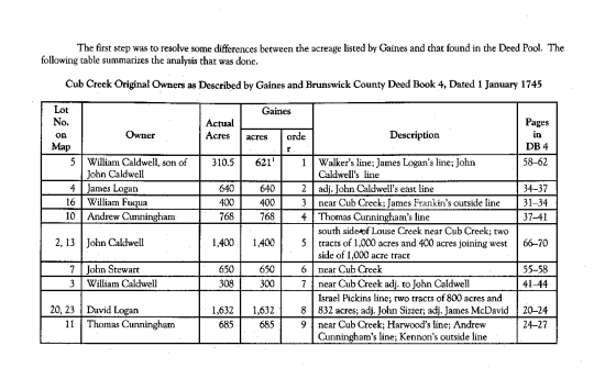
This study, which maps the area where John Caldwell first settled, is based on the work done by Gaines in her history of the Cub Creek Settlement and on previous work done by Dennis Hudgins who mapped some 444 tracts of property in what is today Charlotte County (formerly Lunenburg, formerly Brunswick), Virginia. His material is available in a Deed Pool maintained by Direct Line Software.8 The first seventeen persons who made up Caldwell’s Settlement all purchased their property from Richard and William Kennon, Jr., with Brunswick deeds dated 1 January 1745. The Kennons had patented 31,700 acres in Brunswick County in 1743 on the north side of Staunton River and on both sides of Cub Creek.9
The first step was to resolve some differences between the acreage listed by Gaines and that found in the Deed Pool. The following table summarizes the analysis that was done.
- Howard McKnight Wilson, The Tinkling Spring, Headwater of Freedom, A Study of the Church and Her People, 1732–1952, (Verona, Va.: McClure Press, 1974), 82. William Calwall, Thomas Dougherty, and Israel Pickens all had children baptized at the home of John Caldwell in 1740. Men of these same names were later found as neighbors of John Caldwell on Cub Creek. Wilson, 451, 474, 480.
- Wilson, The Tinkling Spring, 451, 474, 480. This is especially interesting to Finley researchers since the John Finley associated with Tinkling Spring later removes to the Cub Creek sister settlement at Buffalo.
- These data are available through the Deed Pool assembled by Direct Line Software which can be accessed at <http://users.rcn.com/deeds/pool.htm>.
- Virginia Patent Book 23, pp. 647–649.
19
The first step was to resolve some differences between the acreage listed by Gaines and that found in the Deed Pool. The following table summarizes the analysis that was done.
Cub Creek Original Owners as Described by Gaines and Brunswick County Deed Book 4, Dated 1 January 1745
| Lot No. on Map | Owner | Actual Acres | Gaines acres | Gaines order | Description | Pages in DB 4 |
|---|---|---|---|---|---|---|
| 5 | William Caldwell, son of John Caldwell | 310.5 | 6211 | 1 | Walker’s line; James Logan’s line; John Caldwell’s line | 58–62 |
| 4 | James Logan | 640 | 640 | 2 | adj. John Caldwell’s east line | 34–37 |
| 16 | William Fuqua | 400 | 400 | 3 | near Cub Creek; James Franklin’s outside line | 31–34 |
| 10 | Andrew Cunningham | 768 | 768 | 4 | Thomas Cunningham’s line | 37–41 |
| 2, 13 | John Caldwell | 1,400 | 1,400 | 5 | south side of Louse Creek near Cub Creek; two tracts of 1,000 acres and 400 acres joining west side of 1,000 acre tract | 66–70 |
| 7 | John Stewart | 650 | 650 | 6 | near Cub Creek | 55–58 |
| 3 | William Caldwell | 308 | 300 | 7 | near Cub Creek adj. to John Caldwell | 41–44 |
| 20, 23 | David Logan | 1,632 | 1,632 | 8 | Israel Pickins line; two tracts of 800 acres and 832 acres; adj. John Sizer; adj. James McDavid | 20–24 |
| 11 | Thomas Cunningham | 685 | 685 | 9 | near Cub Creek; Harwood’s line; Andrew Cunningham’s line; Kennon’s outside line | 24–27 |
| 15 | James Franklin | 567 | 567 | 10 | near Cub Creek; adj. James Ferriss; Andrew Cunningham’s line | 51–55 |
| 14 | Thomas Daughtery | 360 | 360 | 11 | near Cub Creek; adj. Harwood; John Caldwell’s line | 4–7 |
| 19 | Alexander McConel | 217 | 7172 | 12 | near Cub Creek; Thomas Daughtery’s line | 1–3 |
| 21, 22 | Israel Pickins | 643 | 1,6433 | 13 | 237 acres at corner of Joseph Morton’s line; 406 acres near Cub Creek on west side of Wallace’s branch | 27–31 |
| 12 | William Harwood | 323 | 323 | 14 | John Caldwell’s north line; John Caldwell’s west side | 48–51 |
| 9, 24 | Thomas Vernon | 5014 | 501 | 15 | mouth of Louse Creek; west side Cub Creek; Andrew Cunningham’s line; this consists of two parcels of 370 acres and 101 acres | 62–66 |
| 6, 8 | David Caldwell | 584 | 584 | 16 | near Cub Creek; Walker’s line; adj. John Stewart; James Logan; consists of two tracts of 270 acres and 314 acres | 70–73 |
| 17, 18 | Richard Dudgeon | 1,226 | 1,226 | 17 | both sides Cub Creek; two tracts of 870 or 878 acres and 349 acres | 44–48 |
1Brunswick County, Virginia, Deed Book 4: 58–62 does define two parcels of 310.5 acres each, but the second parcel overlays property of William Caldwell, son of John Caldwell. It was omitted in the parcels mapped in the Deed Pool and is omitted here.
2Probably a typographical error.
3Ibid.
4The actual deed does say 501 acres, but describes two parcels of 370 and 101 acres; Brunswick County Deed Book 4:62–64.
MAGAZINE OF VIRGINIA GENEALOGY, Vol. 41, No. 1
Where discrepancies were found between the acreage recorded by Gaines and that found in the deed pool, the deeds themselves were obtained and examined. Some discrepancies were due to the fact that Gaines combined her numbers for individuals who had purchased more than one parcel, as with William Caldwell, John Caldwell, David Logan, Israel Pickins, Thomas Vernon, David Caldwell, and Richard Dudgeon. When the separate parcels from the Deed Pool were combined, the totals for John Caldwell and David Logan were the same as Gaines gave. However, the actual acreage of Israel Pickins was the sum of his two parcels, 237 and 406 acres or 643 acres. Gaines has listed his combined holdings as 1,643 acres, which appears to be a typographical error. Another typographical error in her list appears to be Alexander McConel—717 instead of 217 acres.
Although not an original purpose of this study, it was interesting to note that there are two William Caldwells on this list, only one of whom is designated son of John Caldwell. This is consistent with a study done by Patricia K. Anderson of Tulsa, Oklahoma, of two William Caldwells who left wills in Lunenburg County in 1751 and 1761.14 It is widely accepted that William, son of John Caldwell, left the 1761 will. Anderson, through her analysis, shows that the other William is of an age that precludes his being either the son or the grandson of John Caldwell.
How the second William connects to the other Caldwells in this area is, as yet, unknown. However, there are at least two authors who believe John had a brother, William, in the area. Bell states, “One of the early groups was that led by John and William Caldwell, brothers.”15 Beeman states, “Following the example of those Scot-Irish leaders who had been successful in making Presbyterianism something close to the ‘established’ religion in the Great Valley of Virginia, John Caldwell, and his brother William officially joined the Anglican church while at the same time retaining their Presbyterian faith.”16 However, neither offers proof of his statement that they were brothers. Another possibility is found in the material by Mrs. John Q. Anderson in her Caldwell Workbook. She shows a William Caldwell baptized 10 June 1703, son of William Caldwell and Elizabeth Porter. John Caldwell’s father was Joseph Caldwell and Joseph had a brother, William, who had a son William baptized 10 June 1703. This William would be a first cousin to John Caldwell settler of Cub Creek.17
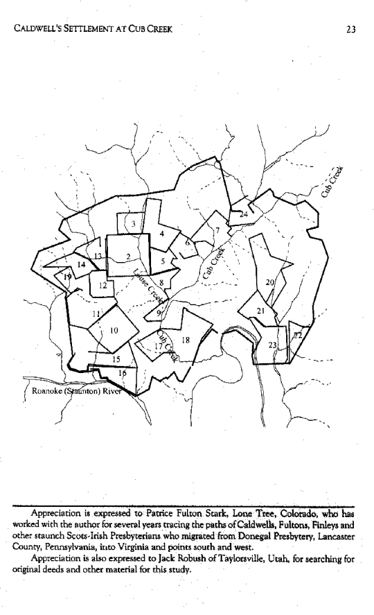
The Original Scots-Irish Presbyterian Settlers of Cub Creek
Using the information from Gaines and a portion of the Deed Mapper pool, the map on the following page shows the location of John Caldwell and sixteen other settlers who purchased the first property.
- Henry and William Caldwell, unpublished manuscript, sent to author in 2002, 3 pp.
- Landon C. Bell, The Old Free State: A Contribution to the History of Lunenburg County and Southside Virginia (Richmond, Virginia: William Byrd Press, 1927), 90.
- Richard R. Beeman, The Evolution of the Southern Backcountry: A Case Study of Lunenburg County, Virginia, 1746–1832 (Philadelphia: University of Pennsylvania Press, 1984), 57–58.
- Mrs. John Q. Anderson, Caldwell Workbook (Houston, Texas: published privately, 1966), 102.
22
CALDWELL’S SETTLEMENT AT CUB CREEK
23
[Map illustration showing numbered tracts (1–24) along Cub Creek, Louse Creek, and the Roanoke (Staunton) River.]
Roanoke (Staunton) River
Cub Creek
Appreciation is expressed to Patrice Fulton Stark, Lone Tree, Colorado, who has worked with the author for several years tracing the paths of Caldwells, Fultons, Finleys and other staunch Scots-Irish Presbyterians who migrated from Donegal Presbytery, Lancaster County, Pennsylvania, into Virginia and points south and west.
Appreciation is also expressed to Jack Robush of Taylorsville, Utah, for searching for original deeds and other material for this study.